
The Geography of Singapore
- Singapore Infomap
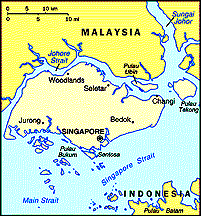
- Location: Southeastern Asia, islands between
Malaysia and Indonesia
- Geographic coordinates: 1 22 N, 103 48 E
- Map references: Southeast Asia
- Area:
- total: 647.5 sq km
- land: 637.5 sq km
- water: 10 sq km
- Area -- comparative: slightly more than 3.5
times the size of Washington, DC
- Land boundaries: 0 km
- Coastline: 193 km
- Maritime claims
- exclusive fishing zone: within and beyond
territorial sea, as defined in treaties and practice
- territorial sea: 3 km
Climate and Terrain
- Descriptions of
Climate, Terrain, Land- and Cityscape in Singaporean
Literature
- Climate: tropical; hot, humid, rainy; no
pronounced rainy or dry seasons; thunderstorms occur on 40%
of all days (67% of days in April)
- Terrain: lowland; gently undulating central
plateau contains water catchment area and nature preserve
- Elevation extremes:
- lowest point: Singapore Strait 0 m
- highest point: Bukit Timah 166 m
Land use:
- Arable land: 2%
- Permanent crops: 6%
- Permanent pastures: NA%
- Forests and woodland: 5%
- Other: 87% (1993 est.)
- Irrigated land: NA sq km
- Natural resources: fish, deepwater ports
Environment
- Current issues: industrial pollution; limited
natural fresh water resources; limited land availability
presents waste disposal problems
- International agreements:
- Party to Biodiversity, Endangered Species,
Hazardous Wastes, Law of the Sea, Nuclear Test Ban, Ozone
Layer Protection, Ship Pollution
- Signed, but not ratified: Climate Change
- Related web resources: Singapore Government
Ministry of the Environment
- geography.com.sg, a web portal on geography for Singapore student
![[Main Web Page]](../../icons/postov2.gif)
![[Singapore]](../icons/sg2.gif)