![]()
[Source of Information: Zimbabwe homepage, which appears taken from CIA World Factbook]
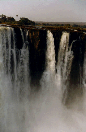

Victorian Falls, August 1997, during Zimbabwe's dry season. During the rainy season, the separate falls become a single continuous mass of falling water. (Click on the pictures to obtain larger images, which take longer to download.) Photographs © George P. Landow may be used without written permission for any educational purpose. Any commercial or other use requires prior written permisison from [email protected].
Location: Southern Africa, northeast of Botswana
Map references: Africa
Area
Land boundaries: total 3,066 km, Botswana 813 km, Mozambique 1,231 km, South Africa 225 km, Zambia 797 km
Coastline: 0 km (landlocked); Maritime claims: none; landlocked
International disputes: quadripoint with Botswana, Namibia, and Zambia is in disagreement
Climate: tropical; moderated by altitude; rainy season (November to March)
 Terrain: mostly high plateau with higher central plateau (high veld);
mountains in east
Terrain: mostly high plateau with higher central plateau (high veld);
mountains in east
Natural resources: coal, chromium ore, asbestos, gold, nickel, copper, iron ore, vanadium, lithium, tin, platinum group metals
Land use
Current issues: deforestation; soil erosion; land degradation; air and water pollution; the black rhinoceros herd -- once the largest concentration of the species in the world -- has been significantly reduced by poaching
Natural hazards: recurring droughts; floods and severe storms are rare
party to -- Biodiversity, Climate Change, Endangered Species, Law of the Sea, Ozone Layer Protection; signed, but not ratified - Desertification